
Chandra Balijepalli [1], Christian Berretta [2], Martin Dallimer [3], Gordon Mitchell [4], Simon Shepherd [5] and Judith Wang [6]
Urbanisation and transport infrastructure development has resulted in increasing coverage by impervious surfaces. The consequent higher volume of runoff, due to reduced infiltration and evapotranspiration, poses serious challenges in urban areas, particularly in the context of climate change, which is changing the timing, duration and intensity of rainfall events. There are risks to infrastructure – buildings, transport networks, and critical infrastructure such as power generation and community assets (e.g. schools, hospitals), and the risk from built infrastructure to the natural environment through erosive flooding, combined sewer overflows, and diffuse urban pollution. Some 28% of UK rivers are designated as heavily modified water bodies, with 91% of these affected by urban water (Ellis et al., 2012). Highways are particularly notable pollutant sources, and with around 143,000 km of urban roads in the UK (Dept. for Transport, 2014) and c. 1500 km2 of impervious surface, it is evident that urbanisation and associated transport system development changes both the quantity and quality of urban storm-water, with consequent risk to both existing infrastructure and the receiving environment.
We propose to study the dynamic relationship between built infrastructure and the natural environment, with a focus on the inter-relationship between urban transport infrastructure and storm-water management (including SuDS) – See Figure 1 for an overview. The mutual influence of these systems, previously considered in isolation, may be examined taking a long term, scalar approach to developing strategies to address the impact of urbanisation on resilience. This is a complex dynamic system, hence a systems analysis approach to planning and decision making is proposed. Systems thinking in ecology has a long history, stretching back to when the term ‘ecosystem’ was first defined by renowned British ecologist Arthur Tansley in 1935 to mean “the whole system, … including not only the organism-complex, but also the whole complex of physical factors forming what we call the environment”.
A key feature of both transport infrastructure and storm-water management is the need for space. In an urban area that comes from re-tooling existing ‘grey’ land uses (buildings, roads, hard surfaces) or, when a city is expanding, by converting green space to newly built infrastructure. However, doing so can have unintended consequences for the city and its residents through the pathways illustrated in Figure 1. Green spaces, such as parks, domestic gardens, playing fields, allotments and even road verges, street trees and brownfield land, play a vital role in making urban living more amenable through their delivery of ecosystem services (e.g., providing places for outdoor recreation, habitat for biodiversity such as birds and pollinating insects, storing and sequestering carbon, improving physical and mental health of city residents and mitigating air and noise pollution; Elmqvist et al 2013; Dallimer et al 2012a,b). Green spaces can also be very important in reducing the risks to infrastructure from natural hazards, such as flooding, and, similarly, mitigating the impact of transport infrastructure on water run-off volumes and quantity.
We therefore also wish to quantify the value (both financially and non-monetarily) of explicitly accounting for and including the roles of green spaces – the ecosystem of the city – when planning transport infrastructure and storm water management. We wish to develop an understanding of risk in the combined system over the long term relevant to spatial planning and climate change, and by developing an improved model for risk-based decision-making, this will contribute to more complete appraisal of investment impact on resilience in these sectors.
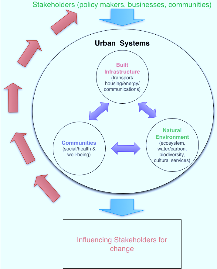
Figure 1: Overview of the urban systems
Objectives
Our research aims to enhance the resilience of urban transport and water systems, both in terms of “engineering resilience” and “ecological resilience” (Wang, 2015), by:
- Determining the interdependency between the urban water management and transport systems in the context of changing climate;
- Developing a systems dynamic approach integrating the urban storm-water and land use/transport systems;
- Assessing the impact of different strategic plan options (land use, transport, storm-water), on resilience and combined system performance, and so inform investment decisions.
The system dynamic approach to the combined transport-water system is a key innovation of the project that offers scope for rapid co-appraisal of a wider range of strategic plan options, potentially addressing different transport modes, development plans (location, land use), green infrastructure (SuDS, permeable surfaces), and storm-water storage. We anticipate investigating (a) options in isolation and in combination, (b) the influence of different level of implementation of strategies, and (c) new and, in particular, extant build where greater physical, economic and social constraints limit scope for single issue solutions, and hence where planning for resilience must take a more integrated systems and geographically broader approach.
Previous research by the team
Land use transport model
Land-use transport interaction (LUTI) models deal with the interdependencies between the land-use (residential, workplace locations) and transport (e.g. road, rail, terminals, stakeholders – users, operators, planners) systems (See Figure 2).

Figure 2: Land use and transport interactions
We use the MARS (Metropolitan Activity Relocation & Simulation) model for Leeds (Pfaffenbichler et al 2010), using system dynamics methodology, recently extended to the wider West Yorkshire conurbation, and this can be used to test options such as road pricing, strategic infrastructure decisions like Metro rail, and can simulate future location of residences/work in response (Balijepalli & Shepherd 2015). We intend to use MARS as the basis of a case study investigating the impact of climate change on the uncertainty associated with infrastructure investment decisions.
Water management system model
SuDS are an important way of controlling not just urban flooding, but discharge of pollutants that build up on urban surfaces, including roads, housing and commercial areas, and are then washed to river. These so called non-point source discharges are one of the main reasons rivers now fail to meet their water quality objectives. SuDS are increasingly implemented in new build developments, but are essential in existing built areas too, if problem discharges are to be tackled. Knowing where retrofit SuDS are needed most is a problem tackled in an urban diffuse pollution model (Mitchell, 2005), driven by land use and traffic data, and an associated probabilistic database of pollutant loadings. The resulting maps (Figure 3) show non-point source hot spots where SuDS are most needed, and have also been integrated with models of point source and agricultural area inputs, and river dispersion models, in whole catchment ‘source apportionment’ analysis, to inform integrated catchment management (Crabtree et al., 2008). The impermeability analysis function of the urban diffuse model has also been used in with the MEPLAN land use transport model, together with a battery of other environmental models, to understand the impact of urban form strategies on issues such as flood risk, atmospheric emission, energy use, and land take (Echenique et al., 2012).

Figure 3: Non-point source hot spots needing SuDS
Figure 3: Non-point source hot spots needing SuDS
Reproduced from OS digital map data, all rights reserved
Storm-water management strategies
In this research we propose to integrate the land use transport interactions and the resulting diffuse pollution analysis to assess strategies to improve the overall resilience of the joint infrastructure system of transport and water management system.
Several research studies investigated strategies for storm-water management in urban areas that aim at reducing runoff volume and controlling diffuse pollution. The findings of these studies will inform the analysis tool implementation and application. The performance of SuDS to control pollutants associated to different land uses (e.g. permeable pavements, adsorptive and absorptive-filtration systems) have been investigated through laboratory and field tests (e.g. Kuang et al., 2007; Berretta et al., 2008; Liu et al., 2009; Berretta and Sansalone, 2012). The long term effect of the implementation of structural (storage tanks) and non-structural solutions (e.g. maintenance practices, mechanical removal of pollutants) on diffuse pollution control was investigated at the catchment scale through a hydrological model with pollutant build-up and transport module that aimed at supporting decision making in storm-water management in urban areas (Berretta, 2006). The hydrological performance of green roofs has been studied through monitoring programmes. The results informed the development of modelling approaches to predict the long term performance (30 years) of green roof systems in different climatic regimes (Stovin et al., 2013) and to simulate the effect of different land use conversion scenarios at the catchment scale (10%, 20%, and 100% impervious to green roofs) (Palla et al., 2008). Commercial hydrological models like the EPA Storm Water Management Model – SWMM (Rossman, 2010) in the recent version (v. 5.1.007) include a SuDS module. SuDS can be assigned to selected sub-catchments by defining the correspondent areal coverage.
Outputs, expected impact
The outputs of the research will include a sketch-planning model of the system to facilitate relatively rapid assessment of the impact of strategic scale investment in infrastructure (housing, transport, drainage/SuDS, urban green infrastructure) on transport and urban water system resilience, performance and cost-effectiveness.
- A supporting database for the case study area, built in collaboration with partners and stakeholders;
- An understanding of combined system-infrastructure resilience under climate change and urbanisation, generated through application of the tool to stakeholder agreed scenarios.
- A more complete understanding of the costs and benefits associated with urban green spaces and their role in the urban water and transport systems, including their additional functions as providers of multiple ecosystem services.
The results of this proposed research could support additional research on addressing complexity in urban systems. Indeed, a key advantage of systems dynamic modelling is the ability to provide a model simulation environment around which multiple stakeholders can come together to conduct rapid evaluation of a wide set of stakeholder generated planning scenarios.
This proposed research considers the urban sub-systems of transport and storm-water management, but we invite expertise across other areas, which could be readily exploited to develop a more integrated model of urban systems resilience, relevant to a wider set of stakeholders.
References
Balijepalli, N.C. and Shepherd, S.P. (2015) Cordon tolls and competition between cities with symmetric and asymmetric interactions. Journal of Transportation. online April 2015 DOI 10.1007/s11116-015-9620-3.
Berretta, C. (2006). Assessment of stormwater runoff impact on receiving water bodies in densely urbanized areas. PhD Thesis, University of Genoa, Italy.
Berretta, C., Gnecco, I., Molini, A., Palla , A., Lanza, L.G., La Barbera, P., (2008) On the efficiency of catch basin inserts for storm water runoff treatment, Proceedings of the 11th International Conference on Urban Drainage, 11ICUD, Edinburgh, 31 August – 5 September 2008.
Berretta, C., Sansalone, J., 2012. Fate of source area runoff phosphorus in a direct adsorptive-filter subject to intra- and inter-event phenomena. Journal of Environmental Management, 103, 83-94.
Crabtree, R W., Kelly, S., Green, H., Mitchell, G. and Squibbs, G. (2008) Cost Benefit Analysis of potential solutions for point and diffuse source pollution to achieve WFD good status: Ribble SIMCAT Pilot Study, UKWIR report WW17C205, 127pp.
Dallimer M, Irvine KN, Skinner AMJ, Davies ZG, Rouquette JR, Armsworth PR, Maltby LM, Warren PH, Gaston KJ. (2012) Biodiversity and the feel-good factor: understanding associations between self-reported human well-being and species richness. BioScience, 62, 47-55.
Dallimer M, Rouquette JR, Skinner AMJ, Armsworth PR, Maltby L, Warren PH, Gaston KJ. (2012) Contrasting patterns in species richness of birds, butterflies and plants along riparian corridors in an urban landscape. Diversity and Distributions, 18, 742-753.
Department for Transport (2014). Road lengths in Great Britain: 2013 data tables, https://www.gov.uk/government/statistical-data-sets/rdl02-road-lengths-kms
Echenique, M., Mitchell, G., Hargreaves, A., and Namdeo, A. (2012). Growing cities sustainably: Does urban form really matter? Journal of the American Planning Association, 78:2, 121-137.
Ellis, J.B., Revitt, D.M., Lundy, L. (2012). An impact assessment methodology for urban surface runoff quality following best practice treatment. Science of the Total Environment, 416 (2012), 172-179.
Elmqvist et al., 2013. Urbanization, Biodiversity and Ecosystem Services: Challenges and Opportunities: A Global Assessment. SpringerLink, The Netherlands.
Mitchell, G. (2005).Mapping Hazard from Urban Non-Point Source Pollution: A Screening Model to Support Sustainable Urban Drainage Planning. Journal of Environmental Management, 74, 1, 1-9
Kuang X., Sansalone J.J., Gnecco I., Berretta C. and L.G Lanza. (2007). Cementitious Permeable Pavement as an LID Practice Hydrologic and Particle In-situ Control. The World Environment & Water Resources Congress – EWRI, May 15-19 2007, Tampa, Florida (USA), 243, 37 (2007)
Liu B., Berretta C., Gnecco I., Ying G., Sansalone, J. (2009) Control of Highway Stormwater during Event and Inter-Event Retention in BMPs. Transportation Research Record: Journal of the Transportation Research Board, 2120, 115-122.
Palla A., Berretta C., Lanza L.G. and La Barbera P. (2008). Modeling storm water control operated by green roofs at the urban catchment scale. ICUD 2008, 11th International Conference on Urban Drainage, Edinburgh, Scotland, UK, August 31 – September 5 2008.
Pfaffenbichler, P., Emberger, G. and Shepherd, S.P. (2010): A system dynamics approach to land use transport interaction modelling: the strategic model MARS and its application. System Dynamics Review vol 26, No 3 (July–September 2010): 262–282.
Rossman, L. A. (2010). “Storm water management model User’s manual, version 5.0.” EPA/600/R-05/040, U.S. Environmental Protection Agency, Cincinnati, OH.
Stovin, V., Poë, S., Berretta, C., 2013. A modelling study of long term green roof retention performance. Journal of Environmental Management, 131, 206-215.
Wang, J.Y.T., 2015. “Resilience thinking” in transport planning. Civil Engineering and Environmental Systems 32(1-2), 180-191 open access to 16th June 2016 http://www.tandfonline.com/r/gcee3212
[1] Institute for Transport Studies, University of Leeds e-mail: N.C.Balijepalli@leeds.ac.uk
[2] Water@Leeds, School of Civil Engineering, University of Leeds e-mail: C.Berretta@leeds.ac.uk
[3] Sustainability Research Institute, School of Earth & Environment, University of Leeds e-mail: M.Dallimer@leeds.ac.uk
[4] School of Geography, and Water@LeedsUniversity of Leeds e-mail: G.Mitchell@leeds.ac.uk
[5] Institute for Transport Studies, University of Leeds e-mail: S.P.Shepherd@its.leeds.ac.uk
[6] Institute for Resilient Infrastructure, School of Civil Engineering and Institute for Transport Studies, University of Leeds e-mail: J.Y.T.Wang@leeds.ac.uk
